North Harbour 2 watermain project
A new watermain in the north and west Auckland areas.
Duration
2025 - 2034
Location
North and west Auckland areas
Status
Planning
Project overview
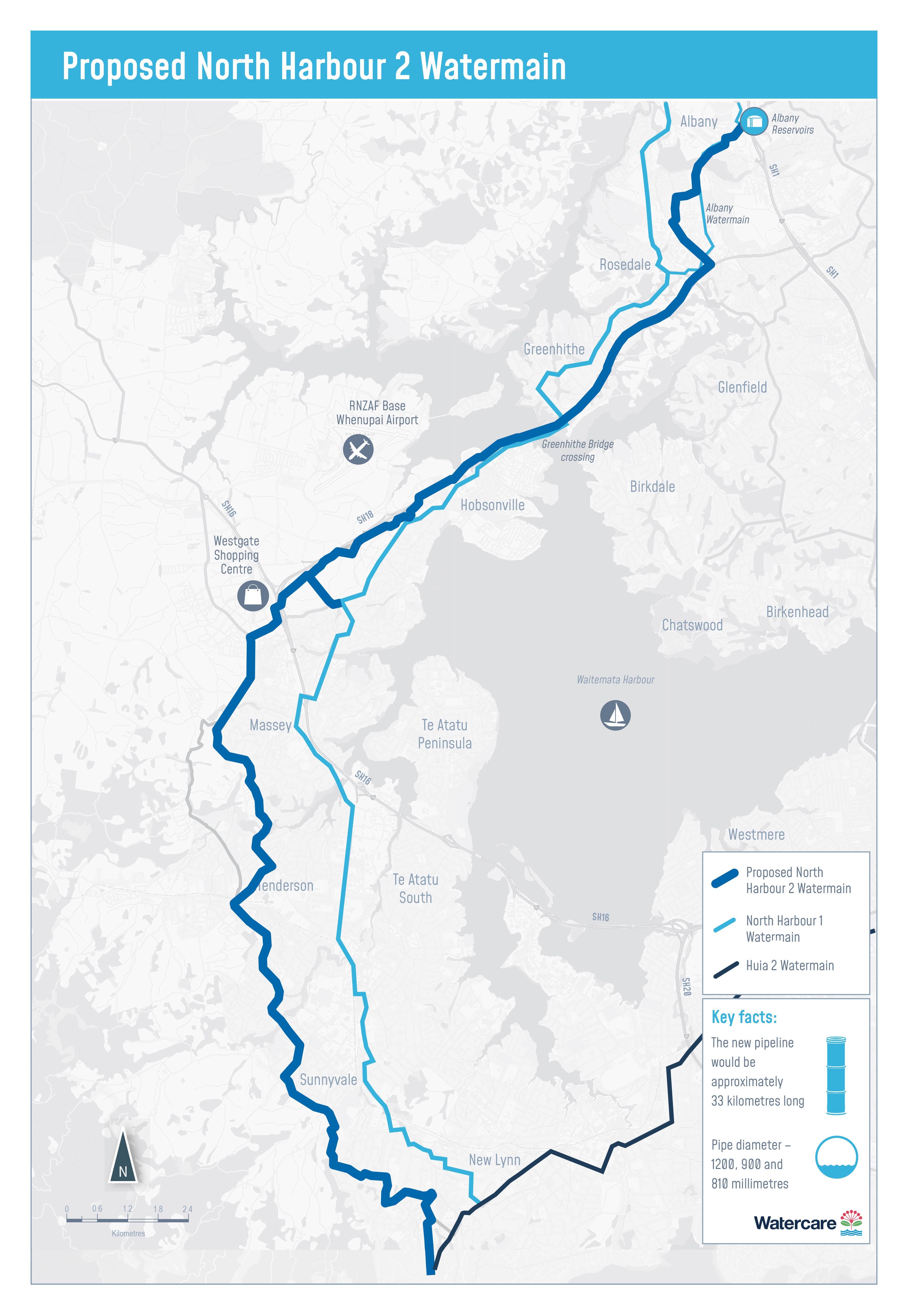
North Harbour 2 (NH2) is a 33km watermain that will service a population increase of 200,000 people in west and north Auckland. NH2 will provide treated water to cater for growth but also provide resilience by duplicating the existing North Harbour 1 (NH1), including a critical section at the Greenhithe Bridge crossing. NH2 will service peak demands along the network, especially in the upper north shore.
Please refer to the map below showing our proposed alignment for NH2.
What’s happening next (2026–2028)
Over the next couple of years, we will continue with:
- Connection and enabling works around Greenhithe Bridge
- Localised construction activities (including Sinton Road and nearby areas)
- Preparation for the main construction phase
Keeping you informed
We will continue targeted communications for:
- Residents near Sinton Road
- Night works as the schedule becomes available
- Properties near The Knoll access route and Greenhithe Bridge work
Project updates
Project updates
Early works for NH2 on Greenhithe Bridge – Stage 1
While our main construction works for the NH2 project are still a while away, our contractor has already completed early works under Greenhithe Bridge as part of the NH2 project. These works involved structural support works in preparation for when we lay the new watermain under Greenhithe Bridge.
Greenhithe Bridge works – Stage 2
What’s happening next
Following early works completed under Greenhithe Bridge, we are progressing to the next stage of works to prepare the network for future connection.
These connection and enabling works include:
- Installing valves, chambers and pipe connections
- Preparing the network so it can be safely operated and maintained in the future
These works are essential to integrate the new watermain into the existing network.
Timing
Early works: June to December 2026
Main works: January 2027 to June 2028
Watercare will remain based at the causeway until December 2026 while early-stage works are completed. The main contractor is scheduled to mobilise in mid-January 2027, meaning the area will continue to operate as an active construction site through to June 2028.
Site works at The Knoll
From June 2026, Watercare will use our property at 15 The Knoll as an access point to the work site.
What to expect:
- Truck movements along the driveway
- Monday to Friday: 6:30am – 6:30pm
- Occasional Saturday works: 7:00am – 3:00pm
The connection and enabling works are expected to take around six months, although access will be required beyond this phase for the ongoing works to install the new pipeline across the bridge, as well as subsequent works through to 2034.
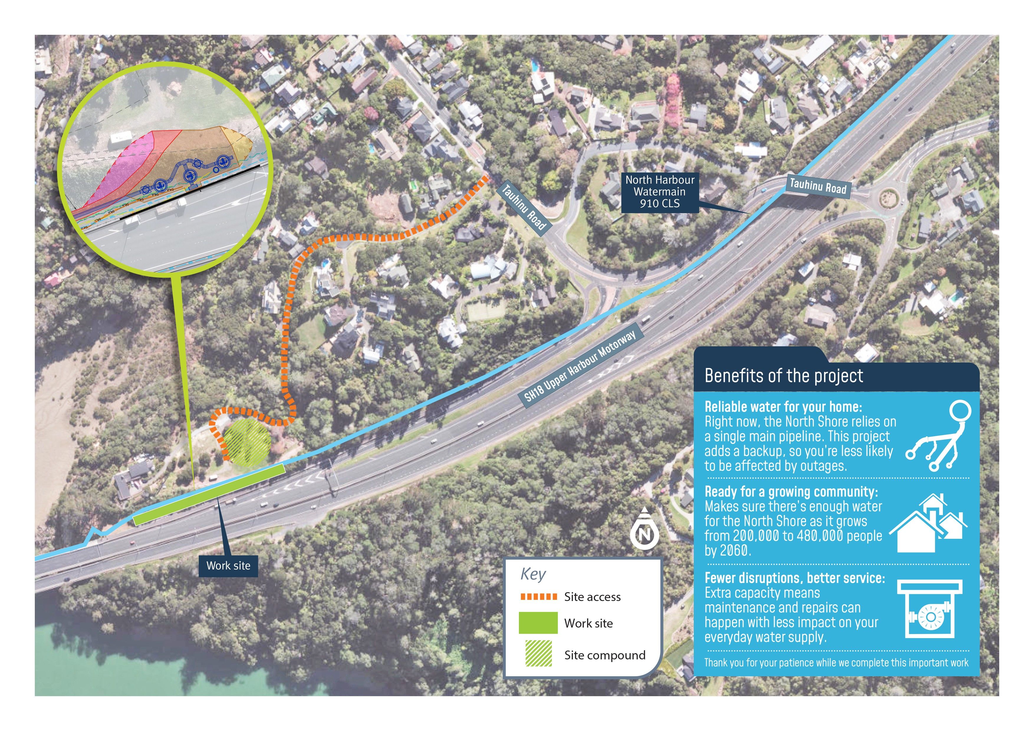
Our contractor will need to access our site compound (as shown on the map below).
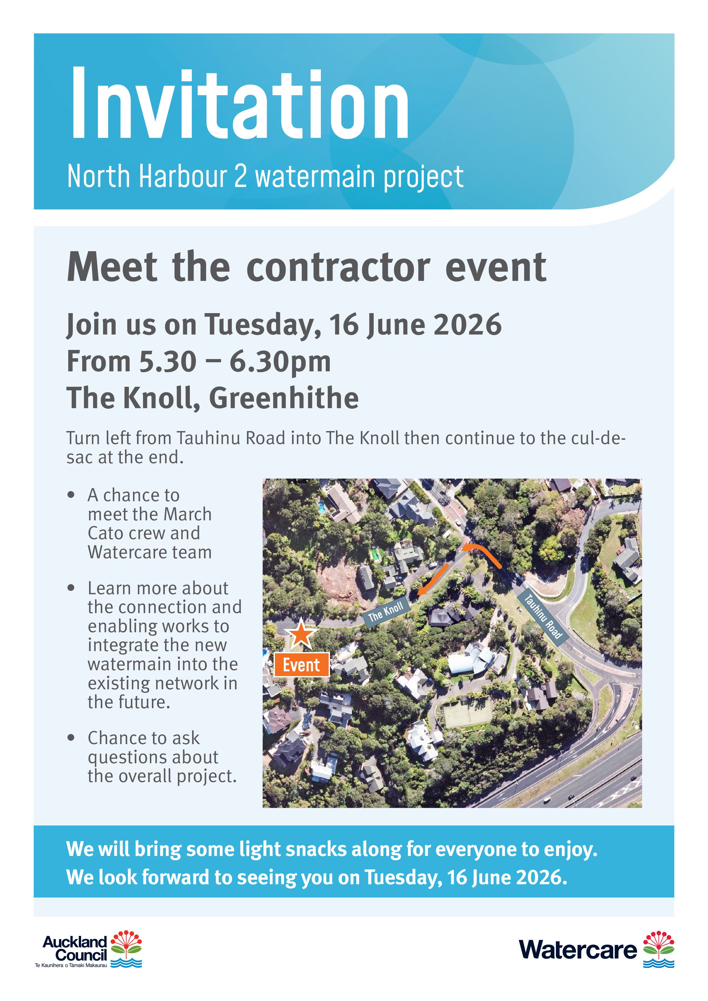
Meet the Contractor
We will be holding a meet the contractor session on Tuesday, 16 June from 5 – 6pm at the turning circle on The Knoll. Please come along if you’d like to learn more about these works.
Sinton Road works
From late May 2026, we will also be carrying out targeted works at Sinton Road to install a new section of pipe into the existing watermain.
What to expect:
- Closure at the end of the Sinton Road cul-de-sac
- Timing: Late May 2026 for approximately two months
- Property access will be maintained throughout construction
- Traffic management will be in place
We ask people to follow signage and directions from traffic management staff to keep everyone safe.
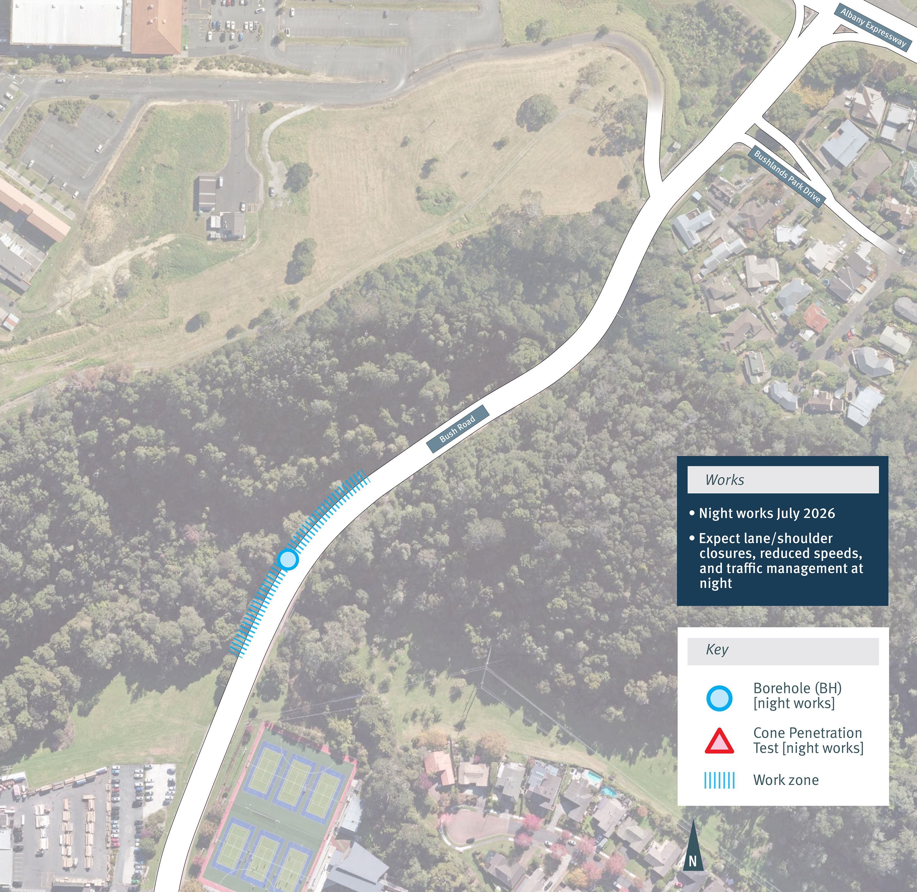
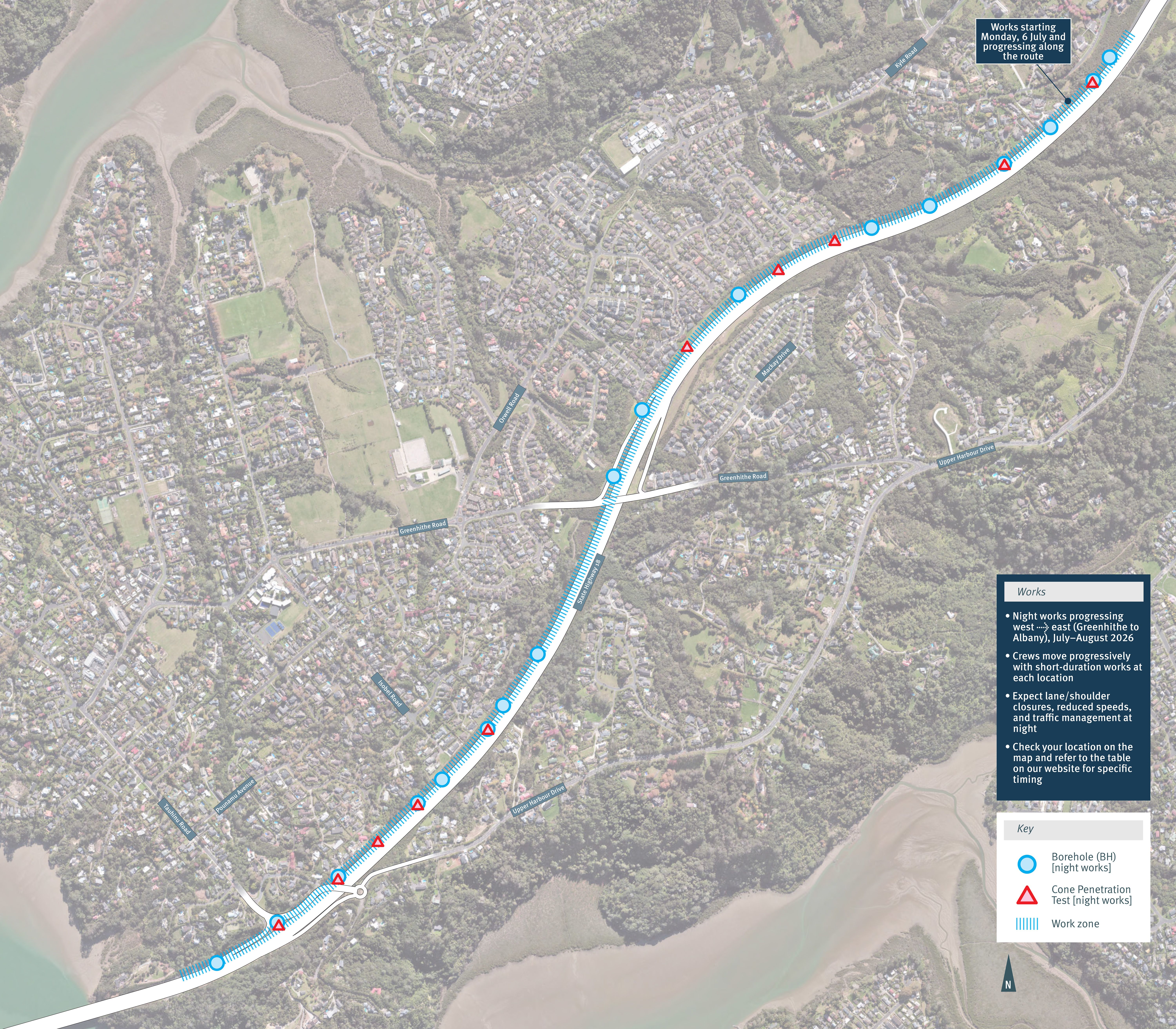
Night works on State Highway 18 and Bush Road, Albany
We will be carrying out targeted geotechnical investigations at night along State Highway 18 (SH18) and Bush Road, Albany to support the design and delivery of the North Harbour 2 (NH2) watermain.
Why night works are required
Most investigations for this project can be completed during the day. However, some locations are close to live motorway lanes, where daytime work would cause significant disruption to traffic.
At the request of NZ Transport Agency Waka Kotahi (NZTA), these works will be completed at night to maintain safety and minimise impacts on road users. Under the project designation, we are also required to notify potentially affected people when night works are taking place.
What’s happening
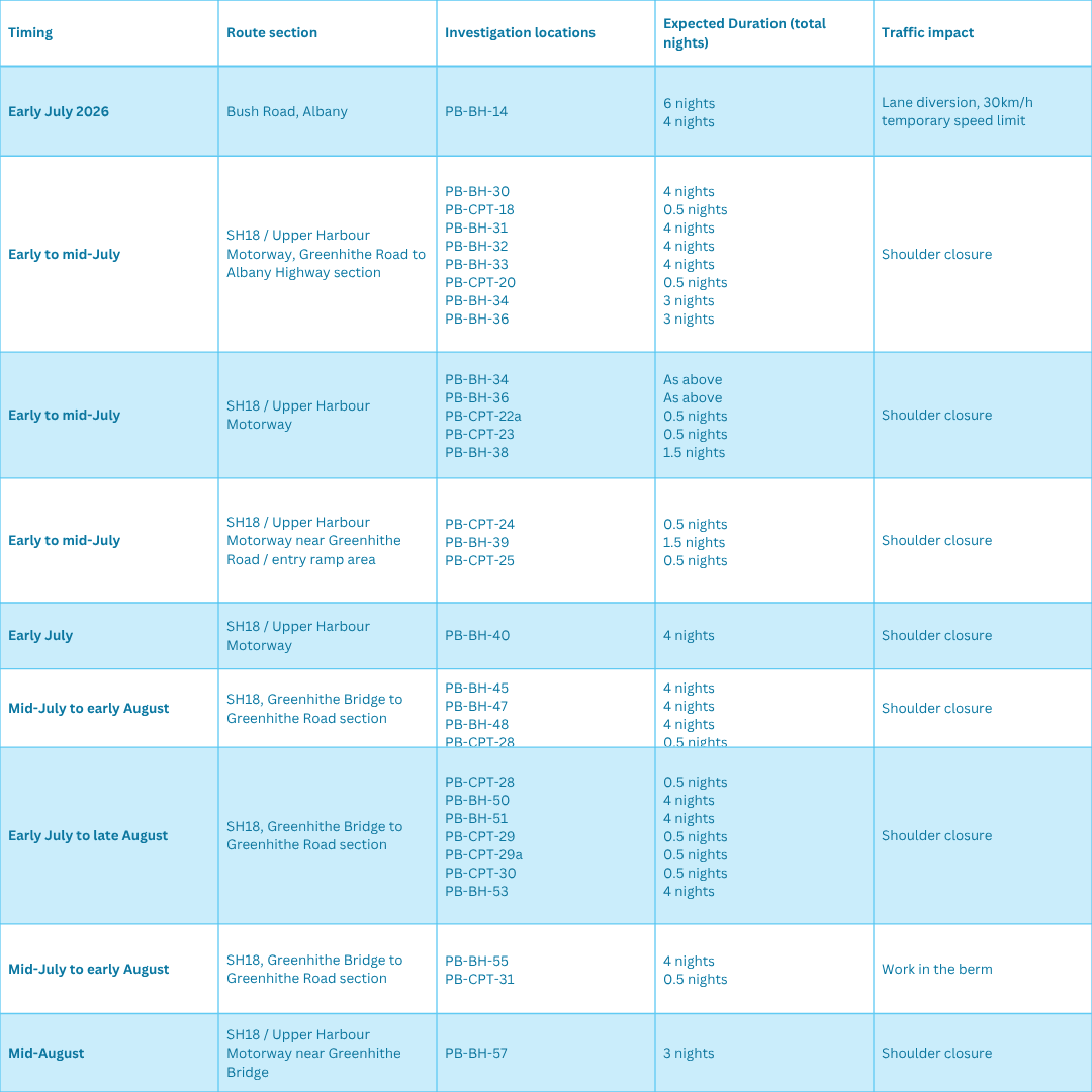
These works involve geotechnical investigations at multiple locations along SH18 and Bush Road to confirm ground conditions and inform the final construction methodology for the watermain.
• Approximately 17 locations will be investigated
• Two sites will be active at any one time
• Each site will typically require 4–5 nights of work
When we’ll be working
Night works are planned to begin from early July 2026 and will run for approximately nine weeks (through to early September 2026).
Traffic management will generally be in place from 11:30pm to 5:00am each night.
Works will progress gradually from west to east, starting near Greenhithe Bridge and moving toward Albany Highway. Timing will be refined as the programme progresses.
How works will progress
Works will move progressively through the corridor:
• Early works: Greenhithe Bridge area (service locating and setup, no drilling)
• Western section: Near Greenhithe Road (short-duration investigations begin)
• Central corridor: Fewer but longer-duration sites
• Peak period: Upper Harbour Drive to Churchouse Road (multiple active sites and consistent overnight works)
• Eastern section: Toward Albany (more intensive investigations, larger equipment)
• Final stage: Albany Highway area (completion of remaining sites)
What to expect
During night works, you may notice:
• Lane closures on SH18 and traffic management on Bush Road
• Reduced speed limits
• Two drilling rigs operating at separate locations
• Support vehicles, including sucker trucks
• Temporary lighting towers
• Crews setting up, working, and packing down each night
Some noise is expected during site setup, pack-down, and drilling activities. While there will be periods of noticeable overnight activity, works are not expected to cause significant or ongoing disturbance.
Managing disruption
We understand night works can be disruptive and will:
• Plan activities to minimise noise and duration where possible
• Complete works efficiently at each location
• Use traffic management and safe work practices to reduce impacts
Works will move progressively, meaning each location will only be affected for a short period before crews move on.
Stay informed
To understand when works will be happening near you:
• Identify your nearest area along SH18 (Greenhithe → Albany)
• Match it to the programme sections below
• Check for updates as timing is confirmed
We appreciate your patience while this essential work is carried out.
Click here to see the full timeline
Please see below for a map of works at Bush Road Albany and on State Highway 18.
Find out more
Please check back regularly for updates or changes to timing as the works progress.