Te tautoko i te tupuranga tonu o Tāmaki Makaurau
Supporting growth in Auckland
We are delivering one of the city’s largest multi-generational infrastructure investment programmes to lift capacity and resilience. Our $13.8 billion programme includes more than 1,000 projects to increase capacity and renew ageing infrastructure.
As we invest at record levels, we also carefully manage existing bulk network capacity – the major pipes, pump stations and treatment plants that provide essential services to whole communities to maintain safe and reliable water and wastewater services. We provide regular updates to give developers and other key stakeholders timely information.
The latest update shows bulk capacity to support planned growth in most of Auckland.
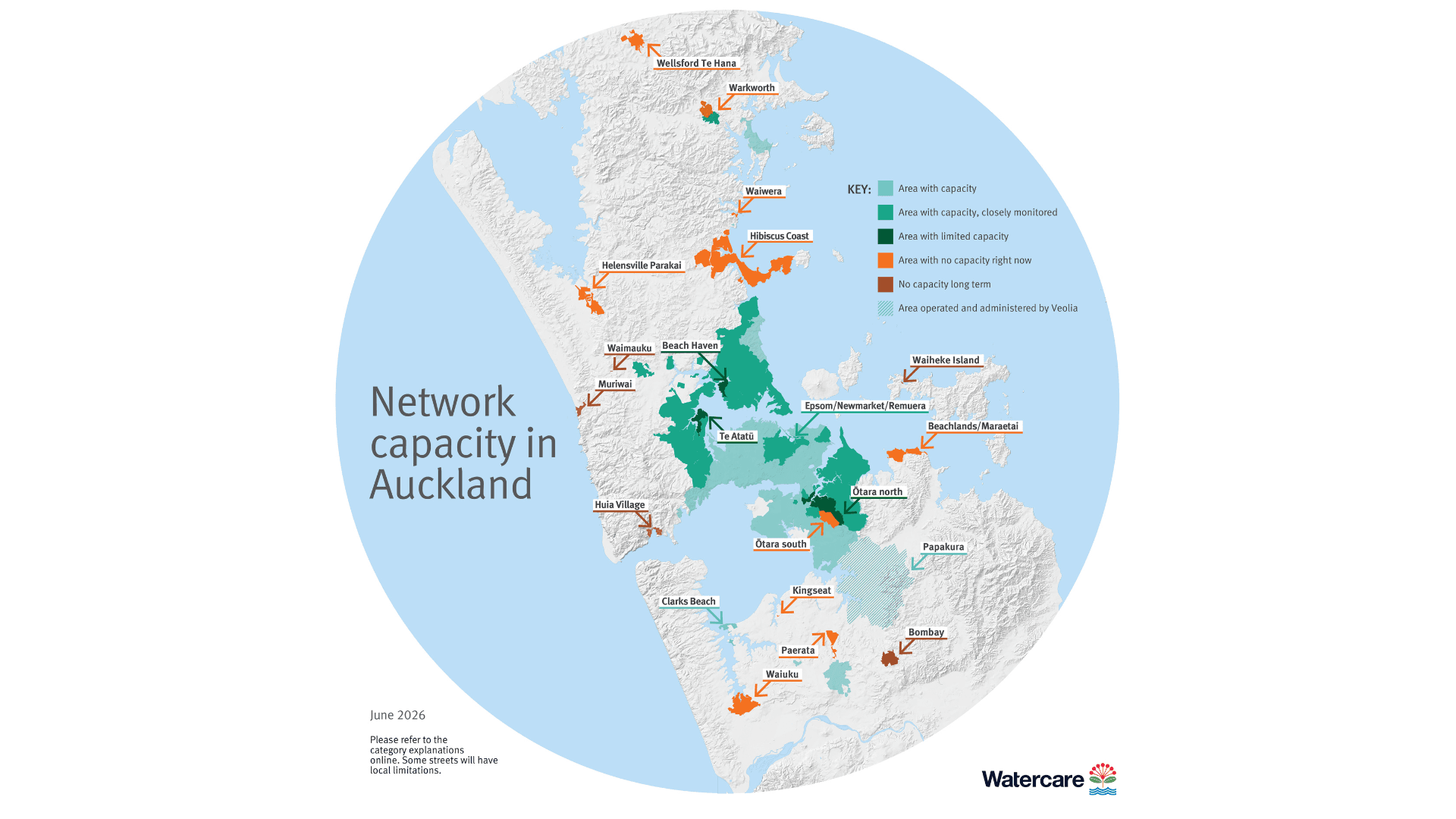
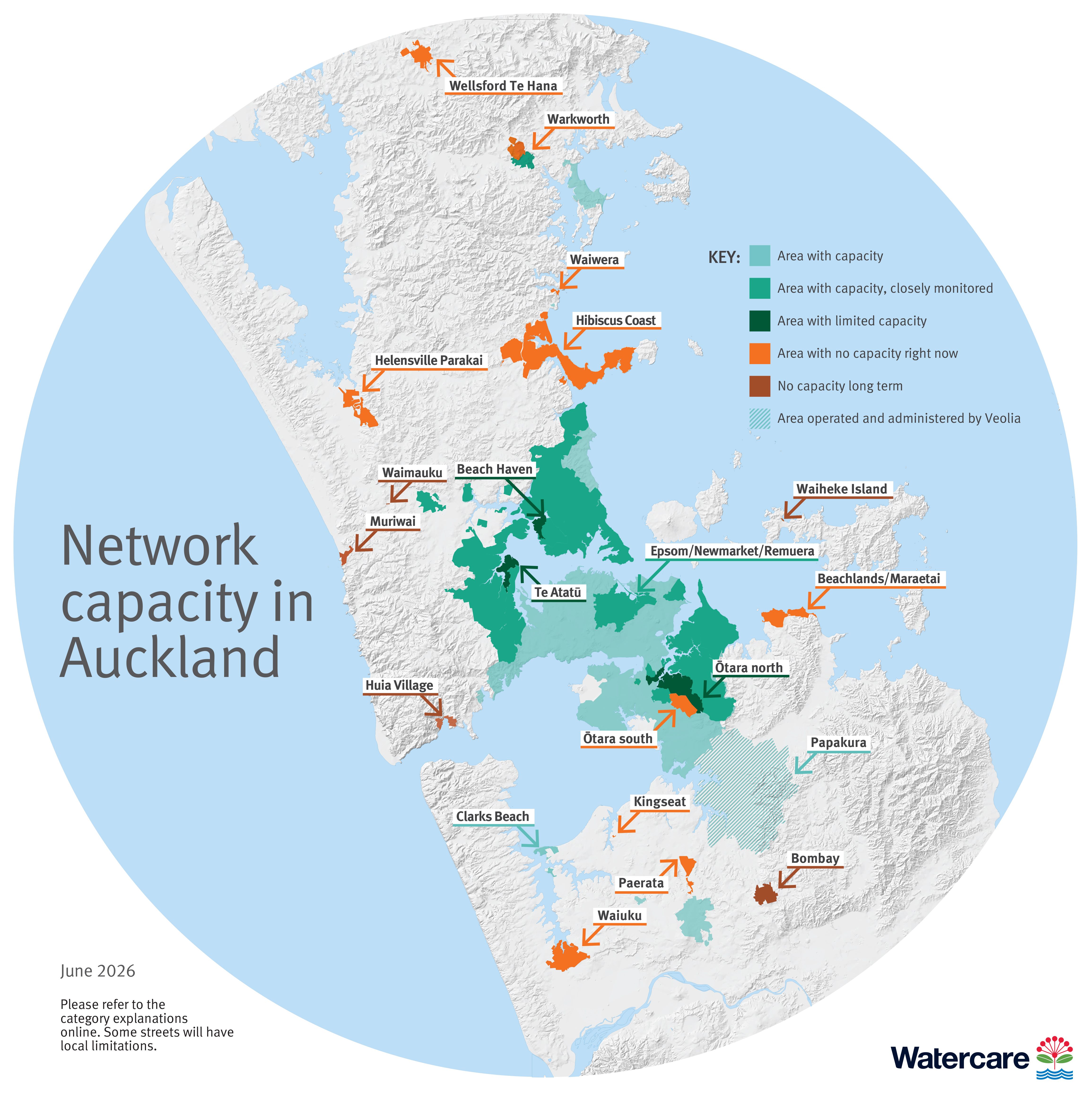
Network capacity in Auckland
The map shows the capacity of the bulk network.
- If you plan to build where capacity is being monitored or is limited, use the capacity tool to understand any effects on your project. Use GIS maps for a detailed view. Select ‘layers list’ then ‘planning areas.’
- Some streets have older pipes which limit local network capacity – the smaller pipes and infrastructure that connect individual streets to the bulk network. You may need to do local network upgrades as part of your resource consent to support new demand from your development. See our consents page to understand the resource consent process or contact us to understand site-specific local network constraints.
- The maps do not assess capacity in future urban areas, as these areas are not currently enabled for growth, and do not cover rural areas as this is outside our servicing area. Please read our Growth Policy for more information on how Watercare services growth.
We also share details of planned infrastructure, so developers know where more capacity is likely to become available. Click on the links to the left find out about projects in particular areas.
Please engage with us early to understand potential impacts on your project – limits to bulk capacity does not automatically mean no new connections. We assess each application on size, demand and timing and can help you plan your project effectively.
Understanding the map categories
Understanding the map categories
Area with capacity
Our bulk infrastructure (treatment plants and large pipes) in these areas generally has capacity to support growth.
The map focuses on capacity at a town or suburb level. Across Auckland, some individual streets may be limited due to bottlenecks in local water or wastewater pipes. We encourage people to assess the impact of their proposed development as part of the resource consent process.
Area with capacity closely monitored
Our bulk infrastructure (treatment plants and large pipes) in these areas is being closely monitored for one or more of these reasons:
- Our data shows that, on average, some locations have more than two wastewater overflows a year.
- Our data indicates that, on average, some locations have more than one but less than two wastewater overflows per year and we anticipate the wastewater network’s performance to decline due to growth in the area.
- There may be limitations in the bulk water supply network.
Our network discharge consent sets a target of no more than two overflows per location per year on average. However, more frequent overflows are permitted by our consent if this is the best practicable option and we have a plan in place to improve the situation.
The map focuses on capacity at a town or suburb level. Across Auckland, some individual streets may be limited due to bottlenecks in local water or wastewater pipes. We encourage people to assess the impact of their proposed development as part of the resource consent process.
This is a new category we’re introducing to provide greater transparency of network capacity.
What this means for potential developers
There is generally capacity in the bulk infrastructure serving these areas, but we are monitoring capacity closely. Some larger developments may be declined at resource consent stage, depending on the specific location and impact to our networks. We encourage anyone wanting to develop in this area to check our online tool as early as possible in their investment process.
It’s possible that these areas could have limitations in the future. We are developing infrastructure programmes to support future growth in these areas.
Area with limited capacity
Our bulk infrastructure (treatment plants and large pipes) in these areas is limited because our data shows that, on average, some locations have more than six wastewater overflows per year, and growth is expected to continue.
Our network discharge consent sets a target of no more than two overflows per location per year on average. However, more frequent overflows are permitted if this is the best practicable option and we have a plan in place to improve the situation.
The map focuses on capacity at a town or suburb level. Across Auckland, some individual streets may be limited due to bottlenecks in local water or wastewater pipes. We encourage people to assess the impact of their proposed development as part of the resource consent process.
What does this mean for potential developers?
In these areas, developments of up to five additional standard houses – or developments with expected wastewater volumes equivalent to up to five standard homes – can go ahead unless there is a bottleneck in a local water or wastewater pipe. Larger developments will be declined at resource consent stage. We will continue to closely monitor capacity and may review this position in the future.
Area with no capacity right now
Our local water or wastewater treatment plants in these areas are nearing or at capacity and/or the area is regularly experiencing overflows on private properties from manholes or gully traps.
The map focuses on capacity at a town or suburb level. Across Auckland, some individual streets may be limited due to bottlenecks in local water or wastewater pipes. We encourage people to assess the impact of their proposed development as part of the resource consent process.
What does this mean for potential developers?
We are planning to replace or upgrade infrastructure to address these capacity limitations and enable growth, however the timeframes for these solutions can vary.
In some cases, such as Warkworth and Wellsford, Auckland Council can still grant resource consents with conditions that no connection can be made to the water or wastewater network until the necessary infrastructure has been delivered.
In most places, developments that already have resource or building consent can proceed as normal. If the resource or building consent was granted on the basis that a public water or wastewater connection would be available, the property will still be able to connect to our services, provided all other consent conditions are met.
On the Hibiscus Coast, where the situation is unique, developments that have building consent can proceed as normal and the property will still be able to connect to our services, provided all other consent conditions are met. Developments with resource consents are encouraged to get in touch with us so we can understand the timing and scale of connections required. No new resource consents are being approved. Click here to learn more.
No capacity long term
These are rural areas with historic constraints that we inherited when we took over the region’s water and wastewater services in 2010. We are not planning to increase network capacity in these areas.
How we plan
We plan in line with Auckland Council’s Future Development Strategy so that we invest in the right areas at the right time. Aligned planning enables us to:
- Deliver reliable essential water and wastewater services now and for future generations
- Plan, fund and sequence infrastructure to support growth
- Protect public health, the environment and respond to climate change
- Reduce the risk of wastewater overflows and system failures – critical as population grows and infrastructure ages.
Questions and answers
Questions and answers
I’m planning to develop in an area that appears to have bulk network limitations. What should I do?
Use the capacity checker before starting your project. It will let you know if you could be impacted. Contact us to understand any site-specific local network constraints.
I’ve already got building consent in an area that is showing limitations. What does this mean for me?
Developments that already have building consent are not impacted. If the building consent was granted on the basis that a public water or wastewater connection would be available, the property will still be able to connect to our services, if all other consent conditions are met.
I’ve got resource consent, but I don’t have engineering plan approval or a building consent. What does this mean for me?
We encourage you to use our capacity checker.
I’m planning to build a new development in an area that appears to have no growth limitations, according to the map. Does that mean I’m fine to proceed?
While there is plenty of capacity to support growth in most parts of Auckland, there are still some very localised limitations. Some individual streets may be limited due to bottlenecks in the local water or wastewater pipes. Assess the impact of your proposed development as part of your resource consent process to identify if you need to upgrade the local network.
See our consents page to understand the key steps in the resource consent process.
I want to build a new development but have been told that no connections to the wastewater network will be available for several years. Can I build an alternative wastewater solution?
Alternative wastewater solutions must meet the Code of Practice to ensure the long-term safety and reliability of the water and wastewater networks. We do not support wastewater tankering or off-peak pumping arrangements. We encourage you to contact us if you are thinking about interim servicing and want to connect to the public network in the future.
Can I pay my infrastructure growth charge early and secure my connection?
No, we cannot hold capacity for a property that is not ready to connect.